Yusufeli Dam |
|
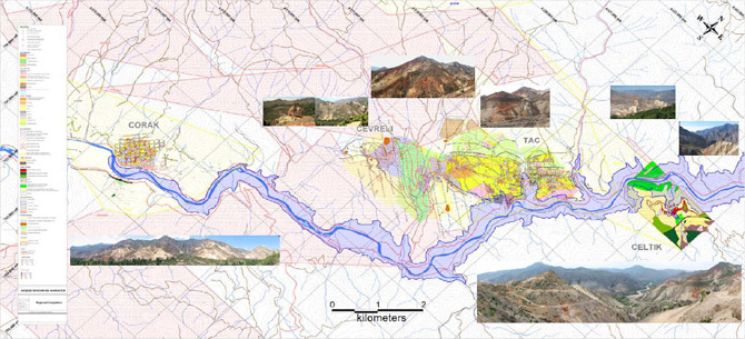
Yusufeli Dam On the Coruh RiverMediterranean Resources Ltd. ("MNR" or the "Company") "Comment from MNR regarding the Turkish Government's plan to dam the Coruh River at Yusufeli and its potential effect on MNR's proposed mining operations". The Turkish Government recently approved the resettlement of the town of Yusufeli (population 6,400) which was the last step in approving the construction of the Yusufeli Dam and Hydro Electric Power Plant (HEPP). This facility is included in the Development Plan of the Coruh River Basin to regulate the Coruh River flow for energy production. This comment is on the effect of this on future operations of MNR in this district. The master plan for the project was completed in 1982 with the Yusufeli dam being one of 10 hydro projects (DSI Paper on Yusufeli Dam and HEPP, July 6, 2006 Rev B, Ankara) planned on the Coruh River which is located in northeast Turkey and flows from Turkey into Georgia and empties into the Black Sea. To date, 2 dams (Muratli and Borcka Dams) have been built close to the Georgian border; one is under construction (Deriner Dam) with the remainder including the Yusufeli Dam planned for construction. The construction of the Yusufeli Dam is expected to commence in 2009. The timing as to when the townspeople and those affected by the location of the dam are to be relocated is indefinite at this stage although the relocation area is defined. The town of Yusufeli is to be relocated and its people resettled approximately 3 kilometres west of its present location. Drinking water and utilization water will continue to be accessed from mountain streams. The Company's Taç and Çorak exploration properties, which lie along a 12 kilometre common mineralized trend held under operating and exploration licenses, are located approximately 12 kilometres and 20 kilometres respectively to the southwest of the town of Yusufeli along the Coruh River. The attached compilation map indicates these properties and their proximities to the river. Also shown is the high water mark post damming which, if construction was to start in 2009, would be reached in approximately 2017, the target date for completing the dam, after allowing 6 years for construction and 2 years to fill the dam to the design level of 713 metres ASL. The Turkish General Directorate of State Hydraulic Works (DSI), under the aegis of the Ministry of Environment and Forestry, has classified the Yusufeli Dam for hydropower production and sediment retention and not as a water pond or dam for drinking water or utilization water purposes. This means the use of "restriction zones" is avoided and, consequently, the Company's mining operations will not be effected by this event other than the consideration that access roads located alongside the river will need to be replaced and, depending on the timing of an open pit mine development at Taç, a retaining wall may have to be built to protect the Taç mining operation. These issues will be contemplated in feasibility studies. It is useful to note that the Company holds operating licenses and operating permits for both Tac and Corak which were issued after the master plan for the power project was finalized in 1982. These licenses and permits are normally issued after the EIA permit has been obtained. The Company believes that, under the environmental rules and regulations prevailing in Turkey, there are no known constraints that will impede the Company's plan to develop Taç and Çorak and its other properties along the mineralized trend through to production.  click to enlarge
|

